Annapurna Base Camp Trek Altitude
There are numerous routes to Annapurna Base Camp. This section will discuss the variations in Annapurna Base Camp Trek - 9 Days altitude encountered on the standard trail. You will drive from Kathmandu to Pokhara and then from Pokhara to Nayapul. The journey starts in Nayapul.
Pokhara to Ulleri
We'll drive from Pokhara to Nayapul, which takes about 2 hours because we have to go over a green hill. From Nayapul, you will take a shared or private 4W jeep to get to Tikhedhunga, which is 1,577m/5,173 feet away. Here, you'll eat lunch, and then you'll walk uphill on stairs for 2 hours and 2:30 minutes until you reach Ulleri, which is 2,020m or 6,627 feet away. The whole walk should take two to three hours. On stairs, you hike down 20 meters (66 feet) and up 443 meters (1,443 feet).
Ulleri to Ghorepani
Today, you'll walk 850m (2,427 feet) uphill and 50m (164 feet) downhill. To get to Ghorepani, you will spend most of the day going up steps and stairs. When you reach Ghorepani, you will have ascended 1500 m in altitude, and the trek will have taken you 5–6 hours to complete. On the trail, there are no open spots, and there aren't many animals. On the trail, though, there are some donkeys that bring up supplies.
From the tea break, the whole way to Ghorepani is uphill. From the tea break all the way up to our lodge at Ghorepani at 2,820m/9,252 feet, it will take about two hours. We will walk through a rainforest and up steps and uneven ground. The total distance from Ulleri to Ghorepani is 10.3km/6.4 miles.
Ghorepani to Poon Hill to Tadapani
From Ghorepani, you will walk to Tadapani. First, you will hike to the top of Poonhill to see the sunrise over the mountains. The top of the hill is 3,210m (10,531 ft) above sea level. Today, we'll get up early and walk up a long flight of stairs to Poon Hill. Depending on how many breaks we take, this will take between 1 and 1.5 hours.
You will have a great view of the sunrise over the beautiful snow-capped mountains. After a short time at Poon Hill, we went back to Ghorepani to eat breakfast.
After breakfast, the hike will keep going uphill and then go through the forest along the ridges. The climb takes us to the Deurali Pass at 3,200m/10,498ft and then to the village of Deurali at 2,960m/9,711ft. From there, we go down to Tadapani at 2,610m/8,562ft. Poon Hill is 2.9 km/1.8 miles up and back down. The total distance for the day is 6.8 miles or 11 kilometers. Today, you will hike up 830 meters, or 2,723 feet, and down 1020 meters, or 3,346 feet.
Tadapani to Chhomrung
You will hike to Chhomrong from Tadapani, which is 2,140m (7,020 feet) above sea level. Trek starts with a steep descent through the rainforest and some small mountain towns. We go down 700m/2,296 feet, which takes a few hours. During this part of the hike, you should be aware that there may be leeches in this area. As the trail gets easier, we'll reach a bridge at 1,900m/6,233 feet and the village of Gurung.
We'll stop for tea in Gurung and then walk for 3 hours uphill to Chhomrung, where we'll stay at a lodge for the night. Today's hike will take about 5 hours, and the total distance for the day is about 6.9 miles/11 km. You will climb 240 meters (787 feet) and descend 740 meters (2,428 feet).
Chhomrung to Dovan
From Chhomrong, you go down to Chhomrong Khola and then uphill for about 4-5 hours to reach Dovan. The hike will take between 5 and 6 hours today. The path goes down very steeply until it reaches the Chhomrung Khola River. We cross a suspension bridge at 1,900m (6,233 feet) and then climb back up steeply on stairs to Sinewa at 2,340m (7,677 feet), where we stop for a cup of tea.
The trail then goes back up until it reaches Khuldighar. We keep going on trails that are both flat and have steep steps up and down until we reach Bamboo at 2,300m/7,546ft. We leave the forest and continue steeply downhill until we reach the village of Dovan at 2,505m/8,218 feet. Today, you'll hike up 700 meters (2,296 feet) and down 450 meters (1,476 feet).
Dovan to Machapuchare Base Camp
We want to make the most of our time up here, so today is a long day. To get to Deurali from Dovan, you have to go uphill and cross the Hotel Himalayan village. We start by climbing through a bamboo forest, then through a rhododendron forest, until we reach Hinku Cave. All of this is 6.7 km/4.2 miles uphill. After lunch, we have another 2 hours and 30 minutes uphill all the way to Machapuchare Base Camp at 3,700m/12,140 feet through the beautiful Annapurna Valley. Today, you'll hike up 1,300 m, or 4,265 feet, and down 240 m, or 787 feet.
Machapuchare Base Camp to Annapurna Base Camp
Today is an enjoyable day because we hike to Annapurna Base Camp at 4,130m/13,550 feet. You will have gained 900 m in height. This is the day when you are most likely to feel the effects of altitude sickness, so be careful. Keep drinking water and move slowly and steadily.
You will go back to Annapurna Base Camp on the same trail or a slightly different one. As you go down, you won't be at risk for altitude sickness, so you can enjoy the hike without worrying about it. If you take that trail back, you can also have fun at the Jhinu hot springs.
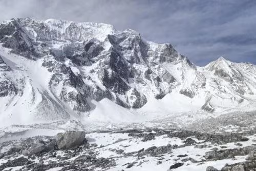
Huge mountains are all around this trail. So, the hike to Annapurna Base Camp is a beautiful one. You walk next to the water that comes from Annapurna's glaciers. There are beautiful flowers and mountains all around you. To get to Annapurna Base Camp, you will have to hike up 430m/1,410 feet.
Annapurna Base Camp to Bamboo
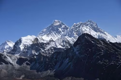
We get up early so we can see the sunrise over the Annapurna mountains. The views of Glacier Dome, Tent Peak, Machhapuchhre, and the Annapurna ranges are out of this world. As the light changes across the Annapurna Range, you can see some stunning views of mountains and glaciers. Then, we start walking from Annapurna Base Camp (ABC) to Bamboo, which is 2,300 meters (7,546 feet) away. We'll be hiking for 6 hours today as we go back to Bamboo. Today, you will hike up 75 meters (246 feet) and down 1,830 meters (5,577 feet).
Bamboo to Jhinu Danda
If you want to get to the Jhinu Hot Springs early in the afternoon, you should start the trek early today. It takes about 5 hours to walk from Bamboo to Jhinu Danda. We will take a break or have lunch in Chhomrung. The trail then goes down very steeply from Chhomrung to Jhinu. Today, you'll walk up 360 meters (1,181 feet) and down 900 meters (2,953 feet).
Jhinu Danda to Pokhara
Today is the last day of your trek. We will walk two hours to Siwai, where the jeep will pick us up. We have to go downhill to get to the river and then back up the other side to a narrow path that leads to the place where we'll be picked up. We drive all the way back to Pokhara from Siwai. It will take about two to two and a half hours to drive this distance. Today, you will go up and down a total of 100 meters (328 feet).
At Last,
Check out our unique itinerary for Annapurna Base Camp 12 days. We skip the places you don't want to walk on so you can spend as much time as possible in the places we know you will love. We've been leading treks in the Annapurna Region for 10 years, so just get in touch. This post about how high you'll get on your Annapurna Base Base Camp Trek should help you get ready. Join us, and we'll make sure you have a great time in the Annapurna area.