The Manaslu circuit trek map is your most important tool during your trek. Cell phone signals are rare in most areas of the trek. That's why Map of Manalsu Circuit trek is essential to complete this Himalayan journey safely.
Manaslu region has minimal infrastructure. You won't find many signposts along the 177-kilometer route. The trail during the Manaslu trek passes through villages. The trail has fewer trekkers than popular routes like Annapurna or Everest. It means less trail maintenance and fewer safety nets if you get lost.
The entire content will show you how to use physical maps and GPX files together for safe navigation. This guide will help you to understand routes from Soti Khola to Dharapani. You'll discover where the checkpoints are located and why they matter to you.
You'll also find out how to download reliable GPX files from trusted sources. You'll get practical tips on using GPS apps offline in the mountains. You'll also learn how to combine digital tools with guide knowledge for the best results.
A reliable map combined with a GPX file gives you confidence on the Manaslu Circuit. These tools help you track your daily progress through remote valleys.
Most importantly, with these tools you will be on correct trail when signposts are missing or damaged.
Why a Good Map Matters during trekking of Manaslu Circuit
The Manaslu Circuit is different from other popular treks in Nepal. You need special permits to trek here because the government controls access. A reliable map is your safety net throughout the trek.
Lets see why the good map really matters in Manaslu Circuit Trek:
- It helps you plan each day's journey carefully.
- It shows you where to stop for lunch breaks.
- It tells you where you can find lodges for overnight stays.
- It warns you about difficult sections ahead.
- Most importantly, it keeps you from getting lost in remote areas.
Digital tools can fail you in the mountains for various reasons. Your phone battery might die in cold weather. Your GPS device might malfunction at high altitude. Weather can damage electronic equipment quickly.
Note: Always carry a physical map as a backup option. Paper doesn't need batteries or charging. It is good for all weather conditions.
For more safety ,you can also load a GPX file on your GPS device or smartphone.
Download offline maps before you start your trek. It’s the second best option.
Restricted Region Rules and Checkpoints of Manaslu
The Manaslu region is a restricted area under government control. The Nepali government limits access to protect the environment and local culture. That’s why you need to hire a registered guide for the entire journey. With registered guides from The Himalayan Odyssey you will have a lifetime experience.
Checkpoints are located at key villages along the route. Officials will check your permits carefully at each stop.
The main checkpoints are positioned at Jagat, Deng, Namrung, Samagaun, and Samdo.
You must pass through all of them during your trek. Our guide will help you with the paperwork at each checkpoint.
The checkpoints serve another important purpose for navigation. They mark confirmed points on your map. It helps to verify your position.
When you reach a checkpoint, you know exactly where you are on the trail. You can also update your position on both your physical map and GPS device.
This regular confirmation helps you track progress accurately.
Never skip your checkpoints, you might be lost or face fines.
Notes: You can mark the main points with a highlighter.Write the expected time to reach each checkpoint. It saves your time and is reliable.
Less Commercialized Than Annapurna/Everest
The Manaslu Circuit receives less trekkers than Annapurna or Everest Base Camp each season. This makes Manaslu more special and authentic. You'll enjoy quieter trails and more cultural experiences.
On the Annapurna Circuit, you'll find clear signposts at every junction. Villages are positioned close together for easy access. Tea houses are enough throughout the route. Help is mostly available. It is same for Everest .
But, Manaslu Circuit presents a different situation entirely. Signposts are rare and often missing. Villages can be far apart with no settlements in between. Some trail sections have no markers at all to guide you.
This lack of commercialization creates both advantages and challenges. The advantage is you get an organic mountain experience without crowds. You see traditional villages that haven't changed much over time. You meet locals who aren't overwhelmed by tourism. The landscape feels wild and untouched by modern development.
The challenge is that navigation becomes comparatively harder here. You can't rely on signs to guide your way forward. You need to check your map often. You need to ask locals for directions at confusing spots. You need to pay attention to natural landmarks for direction.
This reality is why local guides or registered guides are valuable here. They know the current trail conditions from recent trips. They know alternate routes to choose in different scenarios. They can read the landscape and predict weather changes. They communicate with locals in their native language.
Note: A knowledgeable guide makes navigation much easier and considerably safer.
Classic Manaslu Circuit Route Overview
The standard Manaslu Circuit trek takes 13 to 14 days to complete.
You start in Soti Khola and finish in Dharapani on the Annapurna Circuit. The total distance is approximately 177 kilometers of mountain trails. The highest point is Larkya La Pass at 5,106 meters above sea level.
Soti Khola sits at just 700 meters above sea level. Than ,the trail follows the Budhi Gandaki River upstream through the valley.
Each day brings you higher into the mountains gradually. The landscape changes from green valleys to alpine meadows as you climb. Villages become smaller and more remote with each passing day. The air gets thinner and you feel difficult to breath. The temperatures drop slowly as elevation increases.
The route to Manaslu is well-established but not always clearly marked. You'll cross numerous suspension bridges over rushing rivers. You'll climb stone staircases, walk along narrow cliff paths with steep drops. Some days are easy and relaxing while other days are exhausting.
Study your map carefully before you start each day's trek.
The daily stages follows this pattern in Manaslu Circuit.
- Soti Khola to Machha Khola takes about 6 hours.
- Machha Khola to Jagat requires about 6 hours of walking.
- Jagat to Deng takes approximately 6 hours
- Deng to Namrung needs about 6 hours.
- Namrung to Lho is shorter at about 4 hours
- Lho to Samagaun takes about 4 hours.
- You spend an acclimatization day in Samagaun without moving higher. Samagaun to Samdo requires about 4 hours.
- Samdo to Larkya Phedi takes about 4 hours
- Larkya Phedi to Bhimtang via Larkya La is the longest at about 8 hours
- Finally, Bhimtang to Dharapani takes about 6 hours to complete
Major Stops Along the Route
Several villages serve as major stops on the Manaslu Circuit trek.
Machha Khola is your first overnight stop after leaving Soti Khola. Here, village sits beside the river in a narrow valley.
They offer you meals and beds. The altitude is still low at 930 meters.
Jagat marks an important transition point on your journey. This is the first checkpoint village where officials verify permits.
Many tea houses offer hot showers for tired trekkers here. The altitude reaches 1,340 meters here.
Deng signals your entry into the upper valley . The landscape starts to change from this point. You'll see more pine forests covering the hillsides.
The air feels cooler and fresher than before. The altitude reaches 1,860 meters at this village.
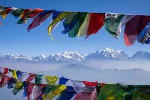
Namrung is where you truly enter the high mountains. This village offers amazing views of majestic Manaslu. You'll start to see Buddhist prayer flags and mani walls everywhere.
The altitude is 2,630 meters at this settlement.
Lho is a beautiful traditional village worth exploring. It has an old monastery worth visiting during your stay. The altitude reaches 3,180 meters here.
Many trekkers start to feel the effects of altitude at Lho.
Sama Gaun is the largest village in the upper valley. You'll spend two nights here to acclimatize properly.
The altitude is 3,530 meters at Sama Gaun. This becomes your launching point for side trips in the area.
Samdo is the last permanent village before the high pass. It's a small Tibetan settlement with unique culture. The altitude reaches 3,860 meters at this point.
From here, you can see into Tibet across the border.
Larkya Phedi is not really a proper village. It's a collection of basic lodges for trekkers. You'll sleep here before crossing the pass early next morning.
The altitude is 4,460 meters at this spot. Facilities are very basic with limited amenities. The night can be very cold and uneasy.
Bhimtang is your first stop after successfully crossing the pass. You'll be tired but relieved to descend to this point.
The altitude drops to 3,720 meters. You will be at ease compared to the altitude. Here, most trekkers sleep very well here after the challenging pass day.
Daily Elevation Profile while trekking Manaslu
Understanding elevation changes is critical for completing the Manaslu Circuit safely. Your map should show elevation for each village along the route. Let’s see a short tabular form to reach Manaslu Elevation:
Day | Start Point | End Point | Start Altitude | Ending Altitude | Altitude Gain |
|---|---|---|---|---|---|
1 | Soti Khola | Machha Khola | 700 m | 930 m | 230 m |
2 | Machha Khola | Jagat | 930 m | 1340 m | 410 m |
3 | Jagat | Deng | 1340 m | 1860 m | 520 m |
4 | Deng | Namrung | 1860 m | 2630 m | 770 m |
5 | Namrung | Lho | 2630 m | 3180 m | 550 m |
6 | Lho | Samagaun | 3180 m | 3530 m | 350 m |
7 | Samagaon (Acclimatize) | Rest stop | - | - | - |
8 | Samagaon | Samdo | 3530 m | 3860 m | 330 m |
9 | Samdo | Larkya Phedi | 3860 m | 4460 m | 600 m |
10 | Larkya Phedi | Bhimtang | 4460 m | 3720 m | 646 m (descend) |
11 | Bhimtang | Dharapani | 3720 m | 1960 m | 1760 m (descend) |
Side Trips Worth Adding to your Trek in Manaslu
The main Manaslu Circuit route is amazing on its own. But, several side trips make the experience even better and memorable.
Side Trips also helps with acclimatization by taking you higher during the day. Your map shows these optional routes for reference. Some of them are:
- Manaslu Base Camp (MBC)
- Birendra Lake
- Pungyen Gompa
- Tibetan Border (Rui La Pass)
- Hinang Gompa & Himalchuli Base Camp
Pungyen Gompa
Pungyen Gompa is a Buddhist monastery located above Samagaun village. The hike takes about 3 to 4 hours for the round trip. The trail climbs through juniper forests with prayer flags. The monastery sits at approximately 4,000 meters above sea level.
The gompa itself is small but beautifully decorated. Monks live here year-round in simple quarters. They welcome visitors with warm butter tea. You can see ancient Buddhist paintings inside the prayer hall. The atmosphere is peaceful and deeply spiritual.
But the real reward is the panoramic view from this location. From the monastery grounds, you can see Manaslu's impressive North face. You can see Tibetan peaks in the distance across the border. You can see the massive glacier that feeds the valley below. On clear days, the view is absolutely breathtaking.
This hike is perfect for acclimatization purposes before the pass.
Manaslu Base Camp
Manaslu Base Camp sits at approximately 4,800 meters above sea level. The hike from Samagaun takes a full day to complete. You need to start early to have enough time for the round trip. The total journey takes 7 to 8 hours including breaks.
The trail follows the valley north from Samagaun village. You pass through yak pastures where herders camp seasonally. You cross rocky terrain that becomes more challenging. The landscape becomes more and more barren as you climb. Eventually you reach the edge of the glacier system.
Base camp is not a permanent settlement with buildings. It's where climbing expeditions set up their camps temporarily.
In climbing season during spring and autumn, you might see tents. Out of season, the area is empty and quiet. But the location is dramatic regardless of the season.
This is a challenging hike that tests your fitness. The altitude affects most people at this height. You need to walk slowly. Not everyone can make it to base camp, and that's perfectly okay.
Your map should show the route to base camp clearly. Mark it with a highlighter so you don't confuse it with other trails. Check with your guide about current conditions before attempting. Sometimes snow or ice makes the route dangerous or impassable.
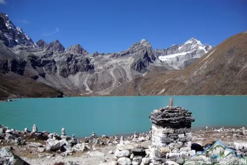
Birendra Lake
Birendra Lake is a beautiful glacial lake near Samagaun village. The hike takes about 4 to 5 hours for the complete round trip. The trail climbs gradually through alpine meadows and rocky areas. The lake sits at approximately 3,700 meters above sea level.
The lake is famous for its stunning color. The water is a brilliant turquoise blue that seems artificial. This color comes from glacial minerals suspended in the water. On sunny days, it's almost unbelievably beautiful to see. The lake is surrounded by peaks on all sides.
Note: This hike is easier than Pungyen Gompa or Base Camp options.
The altitude gain is moderate and manageable. The trail is clear and well-traveled by local herders. Even trekkers who struggle with altitude can usually complete it. This makes it a good option for your acclimatization day activities.
Local people consider the lake sacred in their religion.
The trail starts west of Samagaun village. Our guide will show you the proper starting point. The route is not always marked on standard maps. Ask locals for directions if you're unsure about the way else with us you are always on safe hands.
GPX Data for Trekkers
GPX files have changed how people navigate treks in recent years. GPX stands for GPS Exchange Format in technical terms. These files contain precise location data for entire trails. You can load them onto GPS devices or smartphones easily. They show your exact position on the trail at any moment.
A GPX file for the Manaslu Circuit contains waypoints for every village. It includes the entire trail route from start to finish. It shows elevation data for the complete journey. It marks important landmarks along the way.
The best part is GPX files work even without internet connection available. They use satellite signals to track your positions. This makes them perfect for remote areas like Manaslu. The Manaslu Circuit has no cell phone coverage in many sections. But GPS satellites work everywhere on Earth.
Many modern trekkers prefer GPX files to traditional paper maps. They're more accurate for precise positioning. They update in real time as you move. They can calculate distances automatically for you. They can show your speed and time estimates. They're like having a digital guide in your pocket.
There are cons as well.
GPX files are not perfect navigation solutions. They depend on batteries that can die. They can break if dropped on rocks. They don't show as much contextual detail as paper maps. This is why you should use both paper maps and GPX files together for safety in Manaslu Trek.
Downloadable GPX Files
You can find GPX files for the Manaslu Circuit from several sources online. Some are free to download and use. Others you need to pay for before downloading.
Free GPX files are available on trekking websites and forums. Some are very good and accurate. Others are outdated or contain inaccurate information. Check the date when the file was created and uploaded. Read reviews from other trekkers who used them. Make sure the file includes the entire route without gaps.
Paid GPX files are usually more reliable and accurate. Professional mapping companies create them with expertise. They update them regularly based on current conditions. They include detailed waypoints and helpful notes.
Download your GPX file before you leave for Nepal. Test it on your device to make sure it works properly. Make sure it loads correctly in your chosen app and you can see the full route displayed. Make backups on multiple devices. Email yourself a copy as an additional backup.
How to Use GPX with GPS Devices and Mobile Apps
Several apps can read GPX files on smartphones effectively. The most popular are Maps.me, Gaia GPS, and AllTrails apps.
Choose the one that works best for your needs and comfort level.
Maps.me is free and simple to use for beginners. Download the Nepal map before your trek begins. Load your GPX file into the app. The app will show your position on the trail continuously. It works completely offline without internet. The downside is fewer advanced features than paid apps.
Gaia GPS is a paid app with many advanced features. It has detailed topographic maps for mountainous regions. It can track your route automatically as you walk. It shows elevation profiles for planning. It lets you add notes and photos to waypoints. Many serious trekkers prefer this app for its capabilities.
All trails has both free and paid versions available. The free version has basic navigation features. The paid version includes offline maps and better navigation tools.
Many users like its simple and clean interface as it has a large database of trail reviews from users.
To use any of these apps properly, first download offline maps. Do this while you have wifi in Kathmandu hotels. Download the map for the entire Manaslu region. Then import your GPX file into the app. The app will overlay the trail on the base map.
During your trek, open the app each morning before starting. Check your planned route for the day ahead. Note any important waypoints you'll pass through. Start the tracking feature when you begin walking. The app will show your progress throughout the day automatically. Check your position whenever you reach a junction or feel uncertain.
Some trekkers also carry dedicated GPS devices like Garmin. These are more rugged than phones for mountain use. They have much better battery life for extended trips. They're easier to use with gloves in cold weather. But they're also more expensive than using your phone. For most trekkers, a smartphone with the right app is sufficient.
Practical Navigation Tips
Good navigation combines tools with common sense and experience. Your map and GPX file are valuable navigation aids. But they're not the complete solution on their own. You need to use them correctly in context. You need to combine them with other navigation methods for safety.
Experience matters more than tools in many situations. Our local guide with no GPS can navigate better than a trekker with the latest technology. This is because the guide knows the terrains more clearly. Our guide recognizes even tiny landmarks others miss. The guide can read weather signs and predict changes.
The best approach is to use everything available to you. Use your map for planning and context. Use your GPX file for precise positioning. Listen to your guide's experience and advice. Watch other trekkers for trail confirmation.
Ask locals for current conditions and directions. Pay attention to the trail itself and natural features. All of these together create a reliable navigation system that keeps you safe.
Never rely on just one method for important decisions. Always have backups ready to use.
If your GPS fails, you still have your map. If your map gets wet and damaged, you have your GPS. If both fail completely, you have your guide's knowledge. These ways keeps you safe in the mountains.
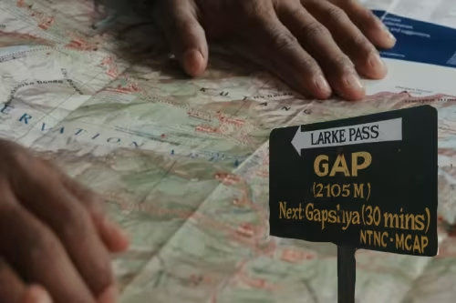
Signposts and Local Guidance in Manaslu Trek
The Manaslu Circuit has some signposts along the route. But they're not common compared to other treks. Don't expect clear directions at every junction. Some signs are old and badly faded. Some point the wrong way due to damage or rotation. Some are in Nepali only without English translation.
When you see a signpost, check it against your map location. Make sure it matches your route and direction. Sometimes signs show distances that seem wrong or impossible. This is because different people measure differently over time. Use signs as rough guides, not exact reliable information.
Trail markers are often more reliable than formal signs. Look for rocks nearby , which are piles of stones stacked by trekkers. Look for colorful prayer flags strung across the trail. Look for painted arrows on rocks and boulders. These markers show where the main trail goes clearly. Local people maintain them as they pass through.
At confusing junctions where trails split, stop and assess carefully. Check your map to see what makes sense geographically. Look at your GPS position to confirm your location. Think about which direction makes sense based on your destination. If you're still unsure after checking, wait for other trekkers to pass or ask locals nearby.
Local people are your best resource for current information. Villagers know every trail in their area intimately. They can tell you about current conditions ahead. They can warn you about dangers like landslides. They can suggest the best route for weather conditions. Always ask politely and remember to say "Thank you (Dhanyawaad)" in Nepali.
Double-check every decision before going to a direction. Take notes about landmarks you pass for reference. Don't take risks at difficult sections of trail.
Combining Maps with Guide Knowledge
Guides are required on the Manaslu Circuit by law. This is actually good news for navigation and safety.
Your guide becomes your most valuable navigation tool throughout the trek. Guides have walked this trail dozens or hundreds of times. They know it in all seasons and various weather conditions.
Guides carry maps for reference and planning. Many now use GPS devices for precise positioning. They combine modern technology with traditional knowledge. This combination gives you the best possible navigation available.
Show the map to your guide each morning during planning. Discuss the day's route and what to expect ahead. Ask about difficult sections that might be challenging. Ask about alternative routes if weather is bad.
Your guide can mark important points on your map with a pen. This helps you learn the route and understand it better.
Many guides don't speak perfect English, especially older ones. Language might be the barrier for you. But they understand maps very well through experience. You can point to locations on the map clearly. You can trace routes with your finger to communicate.
Some trekkers want to navigate independently for the challenge. They want to use their own GPS and maps . This is fine for learning and building confidence. But always consult to your guide in unclear situations or emergencies. Your guide's knowledge is more reliable than any electronic device.
If your GPS battery dies in the cold, your guide knows the way. If your map gets lost or destroyed, your guide remembers the route. If you get confused by any information, your guide clarifies. This human backup is priceless in the mountains.
Battery failure is common in cold mountain weather. Phone batteries drain fast at high altitude and low temperatures. This is why physical maps remain so important today. They work in all conditions without exception. They never need charging or batteries. Always keep your paper map dry and easily available in your pack.
Summary
The Manaslu Circuit offers one of the best treks in Nepal. But it is difficult without good preparation .
Navigation is a key part of that preparation process. You need accurate GPX files for precise positioning. Make sure you know how to use both tools effectively together. Start by getting a good physical map from a reliable source. Download a quality GPX file from a trusted source you can verify.
Combine all your tools for the best results and safety. Use your map to plan each day's route and understand terrain. Use your GPS to track your position in real time. Listen to your guide's advice based on current conditions. Ask locals for information about trail conditions ahead. Watch for trail markers like cairns and prayer flags. This comprehensive approach keeps you safe and on the correct route throughout your journey.
Ready to trek the Manaslu Circuit? Himalayan Odyssey provides complete trekking packages with detailed maps and experienced guides.
Contact us to start planning your adventure.

No comments yet. Be the first to share your thoughts!