Where exactly is Mount Kanchenjunga? Country, State & District Guide
Many people ask "where is Kanchenjunga located?" This question creates confusion for good reason. Kanchenjunga sits on the border between two countries. It spans across different states and districts. This makes its exact location hard to pin down.
Kanchenjunga is not just one mountain peak. It is a massive mountain group called a massif. This massif lies in the eastern Himalaya range. The mountain system includes five major peaks. These peaks spread across international borders.
The simple answer is this: Kanchenjunga is shared between Nepal and India. Nepal's Taplejung district holds the main climbing routes. India's Sikkim state offers the best viewing points. Both countries protect this mountain through national parks and conservation areas.
This guide will clear up all confusion about Kanchenjunga's location. We will cover the country level, state details, and exact districts. You will learn where to find this mountain on any map.
Kanchenjunga at the Country Level
Kanchenjunga lies between two countries: Nepal and India. This creates the main source of location confusion. The mountain massif does not respect political boundaries. It spreads naturally across both nations.
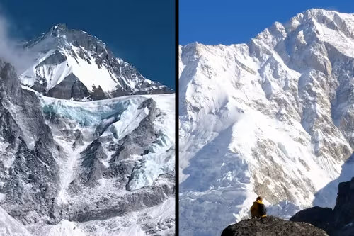
Nepal controls three of the five main peaks. These include the highest summit at 8,586 meters. The main peak, Kanchenjunga I, sits entirely within Nepal. The second highest peak, Kanchenjunga West, also belongs to Nepal. The third peak, Kanchenjunga Central, lies on the border.
India holds two peaks of the massif. Kanchenjunga South and Kanchenjunga Central are visible from Sikkim. These peaks can be seen clearly from many viewpoints in India. However, climbing access comes mainly from the Nepal side.
The mountain sits near a tri-junction point. Nepal, India, and Tibet (China) meet close to this area. This location makes Kanchenjunga strategically important. It also adds to the geographic complexity.
Mount Kanchenjunga is located in which country? The answer is both Nepal and India. Trekkers can access the mountain from either side. Each country offers different experiences and views.
Nepal provides access through the Kanchenjunga Conservation Area. This route leads to both base camps.
Note-Trekkers can reach Pangpema (north base camp) and Ramche (south base camp). Both base camps sit within Nepal's boundaries.
India offers access through Khangchendzonga National Park in Sikkim. This side focuses more on viewing the mountain.
Popular treks lead to Dzongri and Goecha La viewpoints. These locations provide stunning views of the entire massif.
The border location creates unique opportunities for travelers. Some trekkers combine both sides in one journey. This gives them different perspectives of the same mountain system.
Kanchenjunga in Nepal – Taplejung District
Kanchenjunga in Nepal sits within Taplejung district. This district belongs to Province No. 1 in eastern Nepal. Taplejung is a remote mountainous district. It borders both India and Tibet.
The district covers 3,646 square kilometers of rugged terrain. Most of the area lies above 3,000 meters elevation. Taplejung town serves as the district headquarters. This town sits at 1,441 meters above sea level.
Nepal's approach to Kanchenjunga starts from Taplejung. The main trail begins in Taplejung town or nearby villages. Trekkers must first reach this district to start their mountain adventure.
Both Kanchenjunga base camps lie within Taplejung district. Pangpema base camp sits at 5,143 meters elevation. This north base camp offers close views of the main peak. Ramche base camp sits at 4,580 meters. This south base camp provides different angles of the massif.
The Kanchenjunga Conservation Area covers much of Taplejung district. This protected area was established in 1997. It covers 2,035 square kilometers of mountain landscape. The conservation area protects both wildlife and local cultures.
Trekkers need special permits for this area. The Restricted Area Permit costs extra money. The Kanchenjunga Conservation Area Permit is also required. These permits help protect the fragile mountain environment.
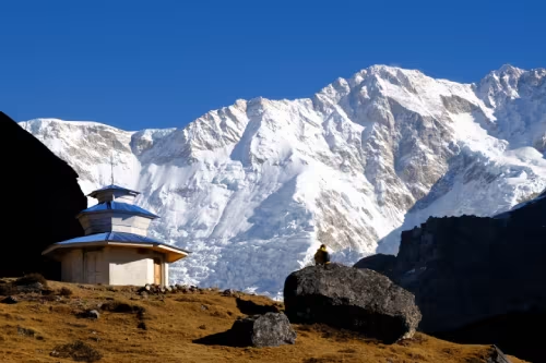
Several cultural villages exist within Taplejung district. Ghunsa village sits at 3,427 meters elevation. This village serves as a major stop on the north route. Yamphudin village lies on the south route. Both villages offer glimpses of local mountain culture.
The people of Taplejung include several ethnic groups. Limbu people are the main inhabitants. Sherpa communities also live in higher villages. These groups maintain their traditional mountain lifestyles.
Kanchenjunga base camp Nepal access requires good planning. The nearest airport is in Bhadrapur. From there, travelers take road transport to Taplejung. The road journey takes 8-10 hours on rough mountain roads.
Kanchenjunga in India – Sikkim State
Kanchenjunga stands as the highest peak visible from India. The mountain holds special importance in Sikkim state. Local people consider it sacred and holy. This reverence has shaped how India manages the mountain.
Kanchenjunga in Sikkim spreads across two districts. North Sikkim district contains the main viewing areas. West Sikkim district also offers mountain views. Both districts provide access to different parts of the massif.
The mountain plays a central role in Sikkim's identity. It appears on the state flag and emblem. Local Lepcha and Bhutia people worship the mountain. They believe spirits live within its peaks.
Climbing restrictions exist on the Sikkim side. The state government respects local religious beliefs. Direct climbing attempts from India are discouraged. This policy protects both the mountain and cultural values.
However, Sikkim offers trekking opportunities. Trails lead to spectacular viewpoints. The Dzongri trek provides close mountain views. The Goecha La trek reaches 4,940 meters elevation.
Yuksom serves as the main trekking base in Sikkim. This historic town sits at 1,780 meters. Yuksom was the first capital of Sikkim kingdom. Today it serves as the gateway for mountain treks.
Khangchendzonga National Park protects the Sikkim side. This park was established in 1977. It covers 1,784 square kilometers of mountain habitat. The park became a UNESCO World Heritage Site in 2016.
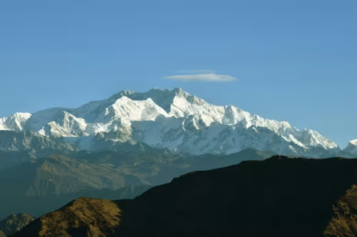
Mount Kanchenjunga in India can be seen from many locations. Darjeeling offers distant but clear views. Pelling provides closer mountain perspectives. Sandakphu gives panoramic views of the entire range.
The visibility depends on weather conditions. Clear days offer stunning mountain views. Monsoon season blocks most views with clouds. Post-monsoon and spring provide the best visibility.
Himalayan Range Context
Kanchenjunga belongs to the Kanchenjunga Himal sub-range. This sub-range forms part of the larger eastern Himalaya. The eastern Himalaya extends from central Nepal to Bhutan.
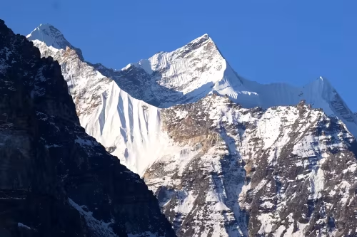
The Kanchenjunga Himal includes several major peaks. Besides the main Kanchenjunga massif, it contains other high mountains. Jannu (7,710m) stands as another prominent peak. Kabru (7,412m) also belongs to this range.
The range connects with the Singalila Ridge system. This ridge forms the border between Nepal and India. It extends from Kanchenjunga toward Darjeeling hills. The ridge offers excellent trekking opportunities.
The Kanchenjunga mountain range supports diverse ecosystems. Tropical forests exist below 1,000 meters. Temperate forests grow between 1,000-3,000 meters. Alpine zones exist above 3,000 meters.
Kanchenjunga on the Map
Finding Kanchenjunga on a map requires knowing key reference points. The mountain sits approximately 125 kilometers east of Mount Everest. This places it in the eastern section of the Nepal Himalaya.
In Nepal, Kanchenjunga appears on maps of Taplejung district. The mountain lies in the far northeast corner of the district. It sits close to both the Indian and Tibetan borders.
On Indian maps, look for North Sikkim district. Kanchenjunga appears near the northern border with Tibet. The mountain also shows on West Sikkim district maps.
The mountain's coordinates are approximately 27°42'N, 88°09'E. These coordinates place it precisely on international borders. GPS devices can locate the exact summit position.
Kanchenjunga in map of Nepal appears in the far eastern region. Province No. 1 contains the entire Nepal portion. The mountain marks the eastern boundary of Nepal's high Himalaya.
Rivers help identify Kanchenjunga's location on topographic maps. The Tamur River flows south from the massif. The Teesta River drains the Sikkim side. These rivers create major valley systems.
Transportation routes also mark the mountain's location. The nearest airport to the Nepal side is Bhadrapur. Bagdogra Airport in India serves the Sikkim side. Road networks from these airports lead toward the mountain.
FAQs on Kanchenjunga's Location
In which country is Kanchenjunga?
Kanchenjunga sits on the border between Nepal and India. Nepal holds three of the five main peaks. India can see two peaks from Sikkim state. Both countries share this mountain massif.
In which state is Kanchenjunga?
In Nepal, it sits in Province No. 1 (formerly called Eastern Development Region). The mountain crosses state and provincial boundaries. In India, Kanchenjunga lies within Sikkim state.
In which district is Kanchenjunga?
Kanchenjunga in Nepal lies entirely within Taplejung district. Taplejung provides the main climbing access routes. In India, it spans North Sikkim and West Sikkim districts.
Which range does Kanchenjunga belong to?
Kanchenjunga belongs to the Kanchenjunga Himal sub-range. This forms part of the eastern Himalaya mountain system. The range extends across the Nepal-India border region.
How far is Kanchenjunga from other famous peaks?
Kanchenjunga sits about 125 kilometers east of Mount Everest. It lies roughly 200 kilometers west of Chomolhari in Bhutan. The mountain occupies a central position in the eastern Himalaya.
What permits are needed to visit Kanchenjunga?
Nepal requires a Restricted Area Permit and Conservation Area Permit. These cost additional fees beyond normal trekking permits.
When is the best time to see Kanchenjunga clearly?
October to December offers the clearest mountain views. March to May also provides good visibility. Monsoon season (June-September) blocks views with clouds and rain.
Conclusion
Kanchenjunga's location spans two countries, multiple states, and several districts. This creates natural confusion about where exactly it sits. The mountain lies between Nepal's Taplejung district and India's Sikkim state. It belongs to the eastern Himalaya range system.
Nepal provides the main access routes for serious trekkers and climbers. Taplejung district contains both major base camps. The Nepal side offers closer encounters with the mountain massif.
The mountain's border location adds complexity to visit planning. Trekkers must consider permits, access routes, and seasonal conditions. Proper preparation ensures successful mountain experiences.
Kanchenjunga rewards visitors with stunning beauty. The mountain's location provides diverse opportunities for adventure and discovery. Its position in the eastern Himalaya makes it a crown jewel of mountain landscapes.